Python 官方文档:入门教程 => 点击学习
GeoTools是ArcGIS地图与java对象的桥梁,恰如jdbc之于oracle与java。 shp文件本身是存有地理对象边界坐标、对象中心城市及城市编号的多多边形字符串。 需要
GeoTools是ArcGIS地图与java对象的桥梁,恰如jdbc之于oracle与java。
shp文件本身是存有地理对象边界坐标、对象中心城市及城市编号的多多边形字符串。
需要使用的依赖如下
 <!-- 添加GeoTools依赖 -->
        <dependency>
            <groupId>org.geotools</groupId>
            <artifactId>gt-shapefile</artifactId>
            <version>${geotools.version}</version>
        </dependency>

        <dependency>
            <groupId>org.geotools</groupId>
            <artifactId>gt-swing</artifactId>
            <version>${geotools.version}</version>
        </dependency>

        <dependency>
            <groupId>dom4j</groupId>
            <artifactId>dom4j</artifactId>
            <version>1.6.1</version>
        </dependency>
        <dependency>
            <groupId>com.alibaba</groupId>
            <artifactId>fastJSON</artifactId>
            <version>1.2.47</version>
        </dependency>
对象:
public class CutProperty {

    private String province;
    private int x;
    private int y;


    private int width;


    private int height;


    private float weight;


    private int rightborder;


    private int bei;


    private int stringsize;
来自@author yukun24@126.com的工具类,读取shp文件:
package com.gwhn.geotools;

import org.geotools.data.FeatureWriter;
import org.geotools.data.FileDataStoreFactorySpi;
import org.geotools.data.Transaction;
import org.geotools.data.shapefile.ShapefileDataStore;
import org.geotools.data.shapefile.ShapefileDataStoreFactory;
import org.geotools.data.simple.SimpleFeatureIterator;
import org.geotools.data.simple.SimpleFeatureSource;
import org.geotools.feature.FeatureCollection;
import org.geotools.feature.simple.SimpleFeatureTypeBuilder;
import org.geotools.referencing.crs.DefaultGeographicCRS;
import org.junit.Test;
import org.locationtech.jts.geom.*;
import org.opengis.feature.Property;
import org.opengis.feature.simple.SimpleFeature;
import org.opengis.feature.simple.SimpleFeatureType;

import java.io.File;
import java.io.Serializable;
import java.NIO.charset.Charset;
import java.util.*;

public class ShapeUtil {

    //读shp文件【几何信息+属性信息】
    public List<Property> SHPRead(String path) throws Exception {
        List<Property> propertyList = new ArrayList<>();
        //基于上面新建的shapfile文件,进行读取

        //构建shapefile数据存储的实例
        ShapefileDataStoreFactory dataStoreFactory = new ShapefileDataStoreFactory();

        //基于路径构建文件对象
        File file = new File(path);

        //构建一个已存在的shapfile数据源
        //ShapefileDataStore:数据存储实现,允许从Shapefiles读取和写入
        ShapefileDataStore ds = (ShapefileDataStore) dataStoreFactory.createDataStore(file.toURI().toURL());

        //设置编码,防止中文读取乱码
        ds.setCharset(Charset.forName("UTF-8"));

        //getFeatureSource():ContentFeatureSource
        //这个特性是由 FeatureCollection提供的操作完成的。单独的特征记忆实现由子类提供:
        //SimpleFeatureSource特征资源明确地使用FeatureCollection【集合】,可迭代
        SimpleFeatureSource featureSource = ds.getFeatureSource();

        //getFeatures():以FeatureCollection的形式检索所有特性。
        //一个用于处理FeatureCollection的实用工具类。提供一个获取FeatureCollection实例的机制
        FeatureCollection<SimpleFeatureType, SimpleFeature> result = featureSource.getFeatures();

        System.out.println("几何对象总共有:" + result.size());
        //features():返回一个FeatureIterator迭代器
        SimpleFeatureIterator it = (SimpleFeatureIterator) result.features();

        while (it.hasNext()) {
            SimpleFeature feature = it.next();
            //迭代属性【属性我们可以理解为一个几何对象的属性节点,也就是对一个几何图形的描述字段】
            Iterator<Property> ip = feature.getProperties().iterator();
//            System.out.println("========================");
            //再来个while
            while (ip.hasNext()) {
                Property pro = ip.next();
//                System.out.println(pro.getName()+" = "+pro.getValue());
                propertyList.add(pro);
            }//end 属性迭代
        }
        it.close();
        return propertyList;
    }

}
来自@author yukun24@126.com的工具类,此处用来将shp中获取的字符串转化为多多边形对象MultiPolyGon
package com.gwhn.geotools;


import org.locationtech.jts.geom.*;
import org.locationtech.jts.io.ParseException;
import org.locationtech.jts.io.WKTReader;

import java.util.List;


//单例模式
public class GeometryCreator {

    public static GeometryCreator geometryCreator = null;

    private GeometryFactory geometryFactory = new GeometryFactory();

    public GeometryCreator() {
    }


    public static GeometryCreator getInstance() {
        if (geometryCreator == null) {
            return new GeometryCreator();
        }
        return geometryCreator;
    }


    public Point createPoint(double x, double y) {
        Coordinate coord = new Coordinate(x, y);
        Point point = geometryFactory.createPoint(coord);
        return point;
    }


    public Point createPointByWKT(String PointWKT) throws ParseException {
        WKTReader reader = new WKTReader(geometryFactory);
        Point point = (Point) reader.read(PointWKT);
        return point;
    }


    public MultiPoint createMulPointByWKT(String MPointWKT) throws ParseException {
        WKTReader reader = new WKTReader(geometryFactory);
        MultiPoint mpoint = (MultiPoint) reader.read(MPointWKT);
        return mpoint;
    }


    public LineString createLine(double ax, double ay, double bx, double by) {
        Coordinate[] coords = new Coordinate[]{new Coordinate(ax, ay), new Coordinate(bx, by)};
        LineString line = geometryFactory.createLineString(coords);
        return line;
    }


    public LineString createLineByWKT(String LineStringWKT) throws ParseException {
        WKTReader reader = new WKTReader(geometryFactory);
        LineString line = (LineString) reader.read("LINESTRING(0 0, 2 0)");
        return line;
    }


    public MultiLineString createMLine(List<Coordinate[]> list) {

        MultiLineString ms = null;


        if (list == null) {
            return ms;
        }

        LineString[] lineStrings = new LineString[list.size()];


//      Coordinate[] coords1  = new Coordinate[] {new Coordinate(2, 2), new Coordinate(2, 2)};
//      LineString line1 = geometryFactory.createLineString(coords1);
//
//      Coordinate[] coords2  = new Coordinate[] {new Coordinate(2, 2), new Coordinate(2, 2)};
//      LineString line2 = geometryFactory.createLineString(coords2);

        int i = 0;
        for (Coordinate[] coordinates : list) {
            lineStrings[i] = geometryFactory.createLineString(coordinates);
        }

        ms = geometryFactory.createMultiLineString(lineStrings);

        return ms;
    }


    public MultiLineString createMLineByWKT(String MLineStringWKT) throws ParseException {
        WKTReader reader = new WKTReader(geometryFactory);
        MultiLineString line = (MultiLineString) reader.read(MLineStringWKT);
        return line;
    }


    public Polygon createPolygonByWKT(String PolygonWKT) throws ParseException {
        WKTReader reader = new WKTReader(geometryFactory);
        Polygon polygon = (Polygon) reader.read(PolygonWKT);
        return polygon;
    }


    public MultiPolygon createMulPolygonByWKT(String MPolygonWKT) throws ParseException {
        WKTReader reader = new WKTReader(geometryFactory);
        MultiPolygon mpolygon = (MultiPolygon) reader.read(MPolygonWKT);
        return mpolygon;
    }


    public MultiPolygon createMulPolygonByPolygon(Polygon[] polygons) throws ParseException {

        return geometryFactory.createMultiPolygon(polygons);
    }


    public GeometryCollection createGeoCollect(Geometry[] geoArray) throws ParseException {
//            LineString line = createLine(125.12,25.4,85.63,99.99);
//            Polygon poly    =  createPolygonByWKT("POLYGON((20 10, 30 0, 40 10, 30 20, 20 10))");
//            Geometry g1     = geometryFactory.createGeometry(line);
//            Geometry g2     = geometryFactory.createGeometry(poly);
//            Geometry[] geoArray = new Geometry[]{g1,g2};
        GeometryCollection GC = geometryFactory.createGeometryCollection(geoArray);
        return gc;
    }


    public Polygon createCircle(double x, double y, final double RADIUS) {

        final int SIDES = 32;//圆上面的点个数

        Coordinate coords[] = new Coordinate[SIDES + 1];
        for (int i = 0; i < SIDES; i++) {
            double angle = ((double) i / (double) SIDES) * Math.PI * 2.0;
            double dx = Math.cos(angle) * RADIUS;
            double dy = Math.sin(angle) * RADIUS;
            coords[i] = new Coordinate((double) x + dx, (double) y + dy);
        }
        coords[SIDES] = coords[0];
        //线性环
        LinearRing ring = geometryFactory.createLinearRing(coords);
        Polygon polygon = geometryFactory.createPolygon(ring, null);
        return polygon;
    }


    public LinearRing createLinearRingByWKT(String ringWKT) throws ParseException {
        WKTReader reader = new WKTReader(geometryFactory);
        LinearRing ring = (LinearRing) reader.read(ringWKT);
        return ring;
    }

}
有xml如下:
<?xml version="1.0" encoding="UTF-8"?>
<application>
    <!-- 网络配置-->
    <module name="Http">

        <group name="FileExport">
            <configValue key="ShapePath">D:/testspace/spd/rain/</configValue>
            <configValue key="ProvinceShapePath">D:/testspace/spd/Provinces_shp/</configValue>
            <configValue key="ProvincePath">D:\testspace\spd\output\</configValue>
            <configValue key="ExportPath">D:\testspace\spd\Export\</configValue>
            <configValue key="PropertyPath">D:\testspace\spd\Export\</configValue>
        </group>

    </module>
</application>
xml读取以获取shp文件位置和图片输出位置:
package com.gwhn.Util;

import org.dom4j.Attribute;
import org.dom4j.Document;
import org.dom4j.Element;
import org.dom4j.Text;
import org.dom4j.io.SAXReader;

import java.io.File;
import java.util.Iterator;


public class YereeXmlContext {


    public String getXmlValue(String key1, String key2, String key3) {
        try {
            //1.创建Reader对象
            SAXReader reader = new SAXReader();
            //2.加载xml
            String directoryPath = Thread.currentThread().getContextClassLoader().getResource("config.xml").getPath();//获取项目根目录
            Document document = reader.read(new File(directoryPath));
            //3.获取根节点
            Element rootElement = document.getRootElement();
            Element moduleElement = getTargetElement(key1, rootElement);
            Element groupElement = getTargetElement(key2, moduleElement);
            Element configElement = getTargetElement(key3, groupElement);
            Attribute attribute = (Attribute) configElement.attributes().get(0);
            String key = attribute.getValue();
            Text text3 = (Text) configElement.content().get(0);
            String value = text3.getText();
            return value;
        } catch (Exception e) {
            e.printStackTrace();
        }
        return null;
    }


    public Element getTargetElement(String targeTKEy, Element parentElement) {
        Iterator iterator = parentElement.elementIterator();
        Element childElement = null;
        while (iterator.hasNext()) {
            Element element = (Element) iterator.next();
            Attribute attribute = (Attribute) element.attributes().get(0);
            String key = attribute.getValue();
            if (key.equals(targetKey) || key == targetKey) {
                childElement = element;
                break;
            }
        }
        return childElement;
    }
}
核心类:用多边形绘图
package com.gwhn.Util;

import com.gwhn.entity.CutProperty;
import org.locationtech.jts.geom.Coordinate;
import org.locationtech.jts.geom.Geometry;
import org.locationtech.jts.geom.MultiPolygon;

import java.awt.*;
import java.awt.image.BufferedImage;
import java.util.List;


public class PolygonUtil {

    ImageUtils imageUtils = new ImageUtils();
    TxtUtil txtUtil = new TxtUtil();


    public void graphicsByMultiPolygon(String path, List<MultiPolygon> multiPolygonList, CutProperty cutProperty) {
        try {
            int imageWidth = cutProperty.getWidth();// 图片的宽度
            int imageHeight = cutProperty.getHeight();// 图片的高度
            BufferedImage image = new BufferedImage(imageWidth, imageHeight, BufferedImage.TYPE_INT_RGB);
            Graphics2D graphics = (Graphics2D) image.getGraphics();
            graphics.setColor(Color.white);
            graphics.fillRect(0, 0, imageWidth, imageHeight);
            graphics.setColor(Color.black);
            int m = cutProperty.getBei() / 100;
            graphics.setStroke(new BasicStroke(cutProperty.getWeight() * m));//线条粗细
            Font font = new Font("宋体", Font.BOLD, 1200);
            graphics.setFont(font);
            graphics.drawString(cutProperty.getProvince(),  12500, 1500);
            for (MultiPolygon multiPolygon : multiPolygonList) {
                int num = multiPolygon.getNumGeometries();
                for (int i = 0; i < num; i++) {
                    Geometry geometry = multiPolygon.getGeometryN(i);
                    drawPolygon(geometry, cutProperty, graphics);
                }
            }
            imageUtils.createImage(path, image);
            System.out.println(path + ":" + font.getSize());
        } catch (
                Exception e) {
            e.printStackTrace();
        }

    }


    public void drawPolygon(Geometry geometry, CutProperty cutProperty, Graphics2D graphics2D) {
        int m = cutProperty.getBei() / 100;
        Double xtemp = Double.valueOf(cutProperty.getX() * m);
        Double ytemp = Double.valueOf(cutProperty.getY() * m);

        //处理飞地
        if (geometry.toString().contains("),")) {
            String geoStr = geometry.toString();
            String tempStr = geoStr.substring(9, geoStr.length() - 1) + ",";
            while (tempStr.contains("),")) {
                String temp = tempStr.substring(0, tempStr.indexOf("),") + 2);
                tempStr = tempStr.substring(temp.length()).trim();
                Polygon polygon = txtUtil.getPolygonByStr(temp,cutProperty);
                graphics2D.drawPolygon(polygon);
            }
        } else {
            Coordinate[] coordinates = geometry.getCoordinates();
            Polygon polygon = new Polygon();
            Double x, y;
            for (int j = 0; j < coordinates.length; j++) {
                Coordinate coordinate = coordinates[j];
                x = coordinate.getX() * cutProperty.getBei() - xtemp;
                y = cutProperty.getRightborder() * m - coordinate.getY() * cutProperty.getBei() - ytemp;
                polygon.addPoint(x.intValue(), y.intValue());
            }
            graphics2D.drawPolygon(polygon);
        }
    }
}
工具类:处理特殊的边界,一般由飞地、岛屿组成
package com.gwhn.Util;

import com.alibaba.fastjson.JSON;
import com.alibaba.fastjson.JSONArray;
import com.alibaba.fastjson.JSONObject;
import com.gwhn.entity.CutProperty;

import java.awt.*;
import java.io.*;
import java.util.ArrayList;
import java.util.HashMap;
import java.util.List;
import java.util.Map;


public class TxtUtil {

    public Polygon getPolygonByStr(String polygonStr,CutProperty cutProperty) {
        polygonStr = polygonStr.substring(1, polygonStr.length() - 2) + ",";
        List<String> polygonStrList = new ArrayList<>();
        while (polygonStr.contains(",")) {
            String pointStr = polygonStr.substring(0, polygonStr.indexOf(",")).trim();
            polygonStrList.add(pointStr);
            polygonStr = polygonStr.substring(polygonStr.indexOf(",") + 1);
        }
        return transPointStrToPolygon(polygonStrList, cutProperty);
    }

    public Polygon transPointStrToPolygon(List<String> polygonStrList,CutProperty cutProperty) {
        int m = cutProperty.getBei() / 100;
        Double xtemp = Double.valueOf(cutProperty.getX() * m);
        Double ytemp = Double.valueOf(cutProperty.getY() * m);
        Polygon polygon = new Polygon();
        for (String pointStr : polygonStrList) {
            Double x = Double.parseDouble(pointStr.substring(0, pointStr.indexOf(" ")));
            Double y = Double.parseDouble(pointStr.substring(pointStr.indexOf(" ")).trim());
            x = x * cutProperty.getBei() - xtemp;
            y = cutProperty.getRightborder()*m - y * cutProperty.getBei()-ytemp;
            polygon.addPoint(x.intValue(), y.intValue());
        }
        return polygon;
    }

    //读取json文件
    public String readJsonFile(String fileName) {
        String jsonStr = "";
        try {
            File jsonFile = new File(fileName);
            FileReader fileReader = new FileReader(jsonFile);
            Reader reader = new InputStreamReader(new FileInputStream(jsonFile), "utf-8");
            int ch = 0;
            StringBuffer sb = new StringBuffer();
            while ((ch = reader.read()) != -1) {
                sb.append((char) ch);
            }
            fileReader.close();
            reader.close();
            jsonStr = sb.toString();
            return jsonStr;
        } catch (IOException e) {
            e.printStackTrace();
            return null;
        }
    }


    public Map<String, CutProperty> getCutPropertyMap() {
        String path = Thread.currentThread().getContextClassLoader().getResource("property.json").getPath();//获取项目根目录
        String s = readJsonFile(path);
        JSONObject jsonObject = JSON.parseObject(s);
        JSONArray jsonArray = jsonObject.getJSONArray("properties");//构建JSONArray数组
        List<CutProperty> cutPropertyList = jsonArray.toJavaList(CutProperty.class);
        Map<String, CutProperty> cutPropertyMap = new HashMap();
        for (CutProperty cutProperty : cutPropertyList) {
            cutPropertyMap.put(cutProperty.getProvince(), cutProperty);
        }
        return cutPropertyMap;
    }

}
核心类:从读到的shp文件数据中提取字符串转化为多多边形,绘图
package com.gwhn.controller;

import com.gwhn.Util.PolygonUtil;
import com.gwhn.Util.TxtUtil;
import com.gwhn.Util.YereeXmlContext;
import com.gwhn.entity.CutProperty;
import com.gwhn.geotools.GeometryCreator;
import com.gwhn.geotools.ShapeUtil;
import org.locationtech.jts.geom.MultiPolygon;
import org.opengis.feature.Property;

import java.io.File;
import java.util.ArrayList;
import java.util.List;
import java.util.Map;


public class ShpPictureController {
    PolygonUtil polygonUtil = new PolygonUtil();
    TxtUtil txtUtil = new TxtUtil();
    Map<String, CutProperty> cutPropertyMap = txtUtil.getCutPropertyMap();


    public void doNation() {
        YereeXmlContext yereeXmlContext = new YereeXmlContext();
        GeometryCreator geometryCreator = new GeometryCreator();
        String shapePath = yereeXmlContext.getXmlValue("Http", "FileExport", "ProvincePath") + "province.shp";
        ShapeUtil shapeUtil = new ShapeUtil();
        try {
            List<Property> propertyList = shapeUtil.SHPRead(shapePath);
            List<MultiPolygon> multiPolygonList = new ArrayList<>();
            for (int i = 0; i * 8 < propertyList.size(); i++) {
                Property property = propertyList.get(i * 8);
                String valueStr = property.getValue().toString();
                MultiPolygon multiPolygon = geometryCreator.createMulPolygonByWKT(valueStr);
                multiPolygonList.add(multiPolygon);
            }
            String path = yereeXmlContext.getXmlValue("Http", "FileExport", "ExportPath");
            File newFileDir = new File(path);
            //如果不存在 则创建
            if (!newFileDir.exists()) {
                newFileDir.mkdirs();
            }
//            String picturName = imageUtils.genImageName() + ".jpg";
            String picturName = "中国.jpg";
            CutProperty cutProperty = cutPropertyMap.get("中国");
            polygonUtil.graphicsByMultiPolygon(path + picturName, multiPolygonList, cutProperty);
        } catch (Exception e) {
            e.printStackTrace();
        }
        System.out.println("完成");
    }


    public void doProvince() {
        YereeXmlContext yereeXmlContext = new YereeXmlContext();
        GeometryCreator geometryCreator = new GeometryCreator();
        ShapeUtil shapeUtil = new ShapeUtil();
        String shapeDirPath = yereeXmlContext.getXmlValue("Http", "FileExport", "ProvinceShapePath");

        List<File> fileList = new ArrayList<>();
        fileList = getFileList(shapeDirPath, fileList);
        for (int j = 0; j < fileList.size(); j++) {
            File file = fileList.get(j);
            if (file.getName().contains(".shp")) {
                File parentFile = file.getParentFile();
                String province = parentFile.getName();
                System.out.println(province);
                int size = 7;
                if (province.equals("湖北") || province == "湖北" || province.equals("安徽") || province == "安徽") {
                    size = 10;
                }
                CutProperty cutProperty = cutPropertyMap.get(province);
                try {
                    List<Property> propertyList = shapeUtil.SHPRead(file.getPath());
                    List<MultiPolygon> multiPolygonList = new ArrayList<>();
                    for (int i = 0; i * size < propertyList.size(); i++) {
                        String valueStr = propertyList.get(i * size).getValue().toString();
                        MultiPolygon multiPolygon = geometryCreator.createMulPolygonByWKT(valueStr);
                        multiPolygonList.add(multiPolygon);
                    }
                    String path = yereeXmlContext.getXmlValue("Http", "FileExport", "ExportPath");
                    ;
                    File newFileDir = new File(path);
                    //如果不存在 则创建
                    if (!newFileDir.exists()) {
                        newFileDir.mkdirs();
                    }
                    String picturName = province + ".jpg";
                    polygonUtil.graphicsByMultiPolygon(path + picturName, multiPolygonList, cutProperty);
                } catch (Exception e) {
                    e.printStackTrace();
                }
            }
        }
        System.out.println("完成");
    }


    public List<File> getFileList(String dirPath, List<File> fileList) {
        File dir = new File(dirPath);
        if (!dir.exists()) {
            dir.mkdirs();
        }
        for (File file : dir.listFiles()) {
            if (!file.isDirectory()) {
                fileList.add(file);
            } else {
                getFileList(file.getPath(), fileList);
            }
        }
        return fileList;
    }

}
地图坐标截取参数
{
  "properties": [
    {
      "province": "中国",
      "x": 8000,
      "y": 18600,
      "width": 25000,
      "height": 15000,
      "weight": 5.0,
      "bei":350,
      "rightborder": 25000,
      "stringsize": 500
    },
    {
      "province": "上海",
      "x": 12050,
      "y": 21800,
      "width": 23000,
      "height": 16000,
      "weight": 0.8,
      "bei": 10000,
      "rightborder": 25000,
      "stringsize": 500
    },
    {
      "province": "云南",
      "x": 9700,
      "y": 22000,
      "width": 25000,
      "height": 25000,
      "weight": 2.0,
      "bei": 2500,
      "rightborder": 25000,
      "stringsize": 50
    },
    {
      "province": "内蒙古",
      "x": 9000,
      "y": 19000,
      "width": 25000,
      "height": 15000,
      "weight": 3.0,
      "bei": 600,
      "rightborder": 25000,
      "stringsize": 180
    },
    {
      "province": "北京",
      "x": 11515,
      "y": 20830,
      "width": 25000,
      "height": 25000,
      "weight": 1.0,
      "bei": 10000,
      "rightborder": 25000,
      "stringsize": 600
    },
    {
      "province": "吉林",
      "x": 12100,
      "y": 20200,
      "width": 25000,
      "height": 17000,
      "weight": 2.0,
      "bei": 2100,
      "rightborder": 25000,
      "stringsize": 40
    },
    {
      "province": "四川",
      "x": 9600,
      "y": 21500,
      "width": 25000,
      "height": 20000,
      "weight": 2.0,
      "bei": 1900,
      "rightborder": 25000,
      "stringsize": 40
    },
    {
      "province": "天津",
      "x": 11600,
      "y": 20920,
      "width": 25000,
      "height": 25000,
      "weight": 1.0,
      "bei": 10000,
      "rightborder": 25000,
      "stringsize": 600
    },
    {
      "province": "宁夏",
      "x": 10400,
      "y": 20960,
      "width": 20000,
      "height": 25000,
      "weight": 1.0,
      "bei": 4210,
      "rightborder": 25000,
      "stringsize": 40
    },
    {
      "province": "安徽",
      "x": 11350,
      "y": 21500,
      "width": 25000,
      "height": 22000,
      "weight": 1.0,
      "bei": 3300,
      "rightborder": 25000,
      "stringsize": 25
    },
    {
      "province": "山东",
      "x": 11430,
      "y": 21050,
      "width": 25000,
      "height": 20000,
      "weight": 1.0,
      "bei": 2900,
      "rightborder": 25000,
      "stringsize": 35
    },
    {
      "province": "山西",
      "x": 10900,
      "y": 20850,
      "width": 25000,
      "height": 25000,
      "weight": 1.0,
      "bei": 3500,
      "rightborder": 25000,
      "stringsize": 25
    },
    {
      "province": "广东",
      "x": 10750,
      "y": 22400,
      "width": 25000,
      "height": 15000,
      "weight": 1.0,
      "bei": 2200,
      "rightborder": 25000,
      "stringsize": 40
    },
    {
      "province": "广西",
      "x": 10400,
      "y": 22200,
      "width": 25000,
      "height": 18000,
      "weight": 1.0,
      "bei": 2600,
      "rightborder": 25000,
      "stringsize": 35
    },
    {
      "province": "新疆",
      "x": 7200,
      "y": 19800,
      "width": 25000,
      "height": 20000,
      "weight": 2.0,
      "bei": 900,
      "rightborder": 25000,
      "stringsize": 150
    },
    {
      "province": "江苏",
      "x": 11550,
      "y": 21400,
      "width": 25000,
      "height": 25000,
      "weight": 1.0,
      "bei": 4000,
      "rightborder": 25000,
      "stringsize": 25
    },
    {
      "province": "江西",
      "x": 11250,
      "y": 21950,
      "width": 25000,
      "height": 25000,
      "weight": 1.0,
      "bei": 4000,
      "rightborder": 25000,
      "stringsize": 25
    },
    {
      "province": "河北",
      "x": 11250,
      "y": 20600,
      "width": 25000,
      "height": 25000,
      "weight": 1.0,
      "bei": 3000,
      "rightborder": 25000,
      "stringsize": 40
    },
    {
      "province": "河南",
      "x": 10900,
      "y": 21200,
      "width": 25000,
      "height": 23000,
      "weight": 1.0,
      "bei": 2700,
      "rightborder": 25000,
      "stringsize": 25
    },
    {
      "province": "浙江",
      "x": 11800,
      "y": 21800,
      "width": 25000,
      "height": 25000,
      "weight": 1.0,
      "bei": 5000,
      "rightborder": 25000,
      "stringsize": 25
    },
    {
      "province": "湖北",
      "x": 10800,
      "y": 21500,
      "width": 25000,
      "height": 20000,
      "weight": 1.0,
      "bei": 3000,
      "rightborder": 25000,
      "stringsize": 30
    },
    {
      "province": "湖南",
      "x": 10800,
      "y": 21900,
      "width": 25000,
      "height": 25000,
      "weight": 1.0,
      "bei": 3500,
      "rightborder": 25000,
      "stringsize": 25
    },
    {
      "province": "甘肃",
      "x": 9000,
      "y": 20300,
      "width": 25000,
      "height": 25000,
      "weight": 2.0,
      "bei": 1200,
      "rightborder": 25000,
      "stringsize": 70
    },
    {
      "province": "福建",
      "x": 11550,
      "y": 22050,
      "width": 25000,
      "height": 25000,
      "weight": 1.0,
      "bei": 4000,
      "rightborder": 25000,
      "stringsize": 25
    },
    {
      "province": "西藏",
      "x": 7500,
      "y": 21000,
      "width": 25000,
      "height": 15000,
      "weight": 1.5,
      "bei": 1000,
      "rightborder": 25000,
      "stringsize": 100
    },
    {
      "province": "贵州",
      "x": 10350,
      "y": 21900,
      "width": 25000,
      "height": 25000,
      "weight": 1.0,
      "bei": 3200,
      "rightborder": 25000,
      "stringsize": 35
    },
    {
      "province": "辽宁",
      "x": 11850,
      "y": 20500,
      "width": 25000,
      "height": 25000,
      "weight": 1.0,
      "bei": 3300,
      "rightborder": 25000,
      "stringsize": 25
    },
    {
      "province": "重庆",
      "x": 10500,
      "y": 21700,
      "width": 25000,
      "height": 25000,
      "weight": 1.0,
      "bei": 4700,
      "rightborder": 25000,
      "stringsize": 20
    },
    {
      "province": "陕西",
      "x": 10450,
      "y": 21000,
      "width": 25000,
      "height": 25000,
      "weight": 1.0,
      "bei": 2900,
      "rightborder": 25000,
      "stringsize": 25
    },
    {
      "province": "青海",
      "x": 8700,
      "y": 20900,
      "width": 25000,
      "height": 15000,
      "weight": 2.0,
      "bei": 1500,
      "rightborder": 25000,
      "stringsize": 70
    },
    {
      "province": "黑龙江",
      "x": 12000,
      "y": 19500,
      "width": 25000,
      "height": 18000,
      "weight": 1.0,
      "bei": 1500,
      "rightborder": 25000,
      "stringsize": 60
    }
  ]
}测试类
public static void main(String[] args) {
try {
ShpPictureController shpPictureController = new ShpPictureController();
// shpPictureController.doProvince();
shpPictureController.doNation();
} catch (Exception e) {
e.printStackTrace();
}
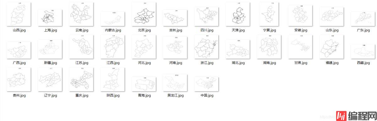
}最终画出的图片效果如下:
到此这篇关于java使用GeoTools读取shp文件并画图的操作代码的文章就介绍到这了,更多相关java读取shp文件并画图内容请搜索编程网以前的文章或继续浏览下面的相关文章希望大家以后多多支持编程网!
--结束END--
本文标题: java使用GeoTools读取shp文件并画图的操作代码
本文链接: https://www.lsjlt.com/news/129590.html(转载时请注明来源链接)
有问题或投稿请发送至: 邮箱/279061341@qq.com QQ/279061341
下载Word文档到电脑,方便收藏和打印~
2024-03-01
2024-03-01
2024-03-01
2024-02-29
2024-02-29
2024-02-29
2024-02-29
2024-02-29
2024-02-29
2024-02-29
回答
回答
回答
回答
回答
回答
回答
回答
回答
回答


官方手机版

微信公众号

商务合作


0